PUBLIC PATH DIVERSION ORDER
HIGHWAYS ACT 1980 SECTION 119(1)
North East Lincolnshire Council
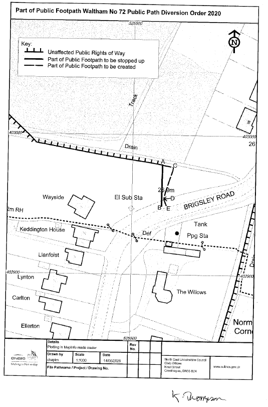
Part of Public Footpath Waltham No 72 Public Path Diversion Order 2020
PUBLIC PATH DIVERSION ORDER
HIGHWAYS ACT 1980 SECTION 119(1)
North East Lincolnshire Council
Part of Public Footpath Waltham No 72 Public Path Diversion Order 2020
This Order is made by the North East Lincolnshire Council (“the authority”) under Section 119(1) of the Highways Act 1980 (“the 1980 Act”) because it appears to the authority that in the interests of the owner of the land crossed by the footpath described in paragraph 1 of this Order, it is expedient that the line of the path should be diverted.
BY THIS ORDER
- The footpath over the land situated at Waltham shown by a bold continuous line on the attached map and described in Part 1 of the Schedule contained in this order (“the Schedule”) shall be stopped up after 28 days from the date of confirmation of this order.
- There shall be at the end of 28 days from the date of confirmation of this order be a public footpath over the land at Waltham described in Part 2 of the Schedule and shown by a bold broken line on the map attached to this order.
SCHEDULE
PART I
Description of Existing Path to be Stopped Up (A- B)
The full width of the Public Footpath commencing on the Brigsley Road at Ordnance Survey Grid Reference 525521 402978 (Point A on the Plan) running in a generally southerly direction for a distance of approximately 29 metres to Ordnance Survey Grid Reference 525521 402949 (Point B on the Plan) where it terminates on the Brigsley Road.
A total distance of 29 metres
PART 2
Description of New Path to be Created (A-C-D-E)
Public Footpath commencing at the unaffected part of Public Footpath 72 at Ordnance Survey Grid Reference 525529 402977 (Point A on the plan) running in a easterly direction for approximately 7metres to Ordnance Survey Grid Reference 525529 402977 (Point C on the plan) the path continues in a south south westerly direction for approximately 24 metres to Ordnance Survey Grid Reference 525523 402954 (Point D on the Plan) the path then turns to a south south easterly direction for approximately 5.5m to Ordnance Survey Grid Reference 525524 402948 (Point E on the plan) joining Brigsley Road.
Width: Two metres except at gates where it narrows to comply the British Standard width.
A total distance of 37 metres
PART 3
Limitations and Conditions
The new section of path described in pat 2 of this schedule to this order is subject to limitation as a gate at:
TA 525529 402975
TA 525523 402954
THE COMMON SEAL of NORTH EAST LINCOLNSHIRE BOROUGH COUNCIL
was hereunto affixed this 22nd day of May 2020 in the presence of:
K. Thompson
Authorised Signatory
Map:
Diversion Order:
Diversion Order 2020 – Footpath number 72 Waltham (PDF, 256KB)


Share this article